| No. tjf_edu2a01 | ||
|---|---|---|
|
Where I Live
Activity 1: The Towns of the Seven Deai Students |
|
| Date: | Country: | Author(copyright): | Themes: |
|---|---|---|---|
| 2001/10 | Japan | The Japan Forum |
Self, Family, and Friends Social Environment Nature and the Environment |
| Overview: | |||
| This activity is designed to deepen students’ understanding of the geographic location and environment of the seven Deai students’ towns. Students find and write in the locations of the towns on the worksheet and match the locations to the accounts of the towns’ special features. | |||
|
|
||||||||||||||||||||||||||||||||
From the Deai photo sheets:
|
||||||||||||||||||||||||||||||||
From the Deai text booklet: |
||||||||||||||||||||||||||||||||
|
Worksheets and other
materials: |
||||||||||||||||||||||||||||||||


|
|
Hang world
maps centered on different parts of the world around the classroom. Use
the maps to illustrate the idea that our way of seeing the world changes as we
change the point from which we look. |
||
|
|
Ask
students to locate Japan and confirm the correct location. |
||
|
|
Prepare
a topographical map of Japan with post-its or
other flags labeled A-G to mark the seven Deai students’ towns. (Refer
to the photo sheet map of the seven Deai students’
towns.) Conceal the names of the towns. Display the map in the room. |
||
|
|
Show
the map of Japan to the students. List their observations about Japan, e.g. latitude
and longitude, location in the northern hemisphere, length from north to south,
surrounded by the sea, mountainous, large or small, climate zone, etc. Encourage
students to make inferences about climate and physical environment. |
||
|
|
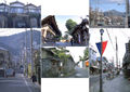
Show the students photographs of the seven Deai students and their towns. Ask the students to guess where the towns are located (north or south, in flatland or mountainous areas, etc.) and to give a reason for their answers, e.g., "I see mountains in the distance so..." or "it’s very flat." etc. Students compare the Deai students’ towns to their own hometowns, e.g., whether they are located in the city or in the country. Students use their observations and match the lettered flags on the maps to the Deai students’ towns.
|
||
|
|
Ask
the students to guess the names of the towns. As they guess, peel off the flags
concealing the town names. |
||
|
|
Distribute Worksheet #1-1. Refer to the column
for Mizushima Yu on the worksheet. Students check the place name: "Yokohama-shi." |
||
|
|
Referring to the photographs, students look at the list on the second page
of Worksheet #1-2 labeled "Machi no tokucho," and choose the Japanese word(s) they think applies to the towns. Review the words
if necessary. |
||
|
|
Students
work in groups of three or four and fill in the sections for the remaining six
Deai students on their own. Encourage students to use the maps, Internet resources,
and other geographic resources. |
||
|
|
On
completion of the worksheet, check the results as a class. Refer to the photo
captions, and the descriptions in the "My Story" sections to answer
any sections students were unable to complete. |
||
|
|
Ask
the students for comments about each of the places they investigated, what caught
their interest, etc. |
||
|
|||
|
| Back to Lesson Plan | | Teacher Support Information | Lessons by TJF | |